


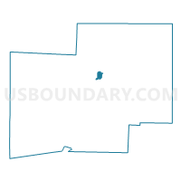
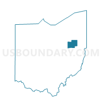
PLAIN TWP 33 Voting District, Stark County, Ohio
About
Outline

Summary
| Unique Area Identifier | 651676 |
| Name | PLAIN TWP 33 Voting District |
| County | Stark County |
| State | Ohio |
| Area (square miles) | 0.93 |
| Land Area (square miles) | 0.93 |
| Water Area (square miles) | 0.00 |
| % of Land Area | 99.82 |
| % of Water Area | 0.18 |
| Latitude of the Internal Point | 40.85199340 |
| Longtitude of the Internal Point | -81.33836870 |
Maps

Graphs
Select a template below for downloading or customizing gragh for PLAIN TWP 33 Voting District, Stark County, Ohio


Neighbors
Neighoring Voting District (by Name) Neighboring Voting District on the Map
- CANTON CITY 6-A Voting District, Stark County, OH
- CANTON CITY 8-I Voting District, Stark County, OH
- PLAIN TWP 13 Voting District, Stark County, OH
- PLAIN TWP 18 Voting District, Stark County, OH
- PLAIN TWP 31 Voting District, Stark County, OH
- PLAIN TWP 34 Voting District, Stark County, OH